Track Charts - Volume 11, Rev-2 - FINAL REVISION! - $10*
Additional Eastern Railroads Maps, Charts and Data
*Now available as a direct download via Dropbox! See main NMRO Products page for details.
Thanks to the efforts of several wonderful individuals, we are again able to offer another great collection of railroad Charts, Profiles and Maps and other highly valuable railroad data.
Featured in this release is a complete set of B&M Condensed Profiles from 1956-1957 showing the details of the railroad at that time. The Second part is a large selection of B&M Line Plans and also signal E-Plans from various parts of the railroad. The remainder of the collection consists mostly of material as shown below.
Many more donations have come in from various sources. This has allowed Volume 11 to be released with more than 1000 images (NOTE: some of these are in PDF form). See the list below for examples and sample images.
![]()
What's in Track Charts Volume 11, Rev-2...?
B&M RR -
Complete set of 1956-57 condensed profiles (187 files);
254 E-Plans from mostly eastern lines of the B&M;
229 Line Plans - Fitchburg Route Main, NH Route Main and Berlin Route;
Land valuation Maps for the Northern Railroad, Concord to Danbury, NH.
Baltimore & Ohio -
Wheeling Branches condensed profiles.
Erie-Lackawanna -
Assorted condensed profiles and maps from around the system.
NKP -
Track diagrams from around the system.
PRR -
A large assortment of condensed profiles and other maps and items from around the PRR system.
NEW MATERIAL (some of it but not all of it)....
More B&M assorted files, maps and other items.
A new map of Claremont, NH showing original proposed street railway routes.
A couple new detail maps from D&H and CN.
Maps of New Hampshires logging railroads (with special thanks to author Bill Gove for these).
Map of the Deerfield River Railroad (again thanks to Bill Gove).
Some Maine Central detail maps showing joint track with Canadian Pacific.
Metro North Railroad track charts book.
Plus more material to finish this CD. This is the FINAL REVISION for TC-11.
1000+ total new images!
NMRO is offering ONE (1) compact disk containing 1000+ images of land valuation maps, track charts and other drawings.
Resolution of all images is mostly 2 and 16 b&w GIF format. If you were to try to obtain these maps anywhere else in paper form it would cost you THOUSANDS of dollars!!! NMRO Products proudly believes that railroad information should be shared as reasonably as possible. Clarification: The data is FREE because it is public domain. NMRO just does the legwork for you.
![]()
Troy, NY CTC era condensed profile sample:

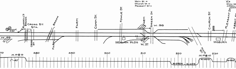
Woburn, MA E-Plan Sample:
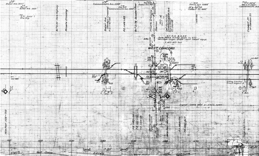
West Concord, MA Line Plan Sample:
Order your copy today by mailing $10 + $2 postage to:
Scott J. Whitney
78 Goret Dr.
Colorado Springs, CO 80911
NOTE 1: International mail orders must include $4 additional postage to Canada & Mexico, Total postage $6.
(NOTE 2: ALL International mail orders outside North America must be by Dropbox download only.)
Or use the handy PayPal links below:
![]()
