Track Charts - Volume 12*
Boston & Albany Railroad Land Valuation Maps and Other Data
*Now available as a direct download via Dropbox! See main NMRO Products page for details.
Thanks to the efforts of some wonderful individuals, we are again able to offer another great collection of railroad Maps. Featured in this release is a selection of Boston & Albany Railroad land valuation maps, track charts, and other data for the entire railrad.
The maps are from many different time periods over the life of the railroads and vary in quality from excellent to almost unreadable (but those are included to act as place holders until future contributions replace them).
In all there are over 1100 files covering 100% of B&A RR trackage from Boston, MA to Albany, NY and including ALL branchlines!!
Most all valuation maps are 9950 pixels wide and have been painstakingly enhanced from their original scans for better viewing and printing conditions. A few maps have been reduced somewhat in an effort to bring out nearly lost details.
![]()
This is the ONLY EDITION for TC-12.
Over 1500 files!
NMRO is offering ONE (1) compact disk containing over 1000 images of land valuation maps.
Resolution of all images is mostly 9950 pixels wide. If you were to try to obtain these maps anywhere else in paper form it would cost you THOUSANDS of dollars!!! NMRO Products proudly believes that railroad information should be shared as reasonably as possible. Clarification: The data is FREE because it is public domain. NMRO just does the legwork for you.
![]()
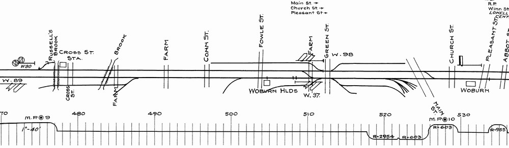
Boston & Albany Sample:
Order your copy today by mailing $10 + $2 postage to:
Scott J. Whitney
78 Goret Dr.
Colorado Springs, CO 80911
NOTE 1: International mail orders must include $4 additional postage to Canada & Mexico, Total postage $6.
(NOTE 2: ALL International mail orders outside North America must be by Dropbox download only.)
Or use the handy PayPal links below:
![]()
