 Track Charts - Volume 14*
More Boston & Maine Railroad Land Valuation Maps
 SPECIAL OFFER - See below for a great deal!!
*Now available as a direct download via Dropbox! See main NMRO Products page for details.
Thanks to the efforts of some wonderful individuals, we are again able to offer another great collection of railroad Maps. Featured in this release is a huge selection of Boston & Maine Railroad land valuation maps from all over the B&M system.
The maps are from many different time periods over the life of the railroad. Most are of very good quality and easy to read. These valuation maps directly supplement those released in previous NMRO Products collections and fill in many of the gaps nicely. Please refer to the release key map below as all new additions are shown in GREEN. Take note that some of the lines around the eastern Mass. area are repeat coverage for lines released in Track Charts 12. However, the new maps are either different or of much better quality or complete rail lines that had only partial coverage previously.
In all there are over 1450 new maps, each covering a mile of railroad trackage. A B&M valuation Key Map is included to see exactly what territories are covered.
Most all maps are about 11,000 pixels wide and have been painstakingly enhanced from their original scans for better viewing and printing conditions. This is a MUST HAVE collection for the true B&M fan and comes at the usual inexpensive NMRO Products price!
![]()
This is the ONLY EDITION for TC-14.
Over 1450 images!
NMRO is offering ONE (1) compact disk containing over 1450+ images of land valuation maps.
Resolution of all images is mostly 11,000+ pixels wide. If you were to try to obtain these maps anywhere else in paper form it would cost you THOUSANDS of dollars!!! NMRO Products proudly believes that railroad information should be shared as reasonably as possible. Clarification: The data is FREE because it is public domain. NMRO just does the legwork and production for you.
![]()
SPECIAL OFFER -
Those ordering via the Dropbox option below will receive not only the valuation maps contained on the CD but also ALL the Boston & Maine valuation maps that are offered by NMRO Products! This includes some mapping that has not been previously released to the public (the ENTIRE Cheshire Branch now)!!
All B&M valuation maps in one group! 2453 files!! 
![]()
Boston & Maine coverage map for CD orders ONLY:
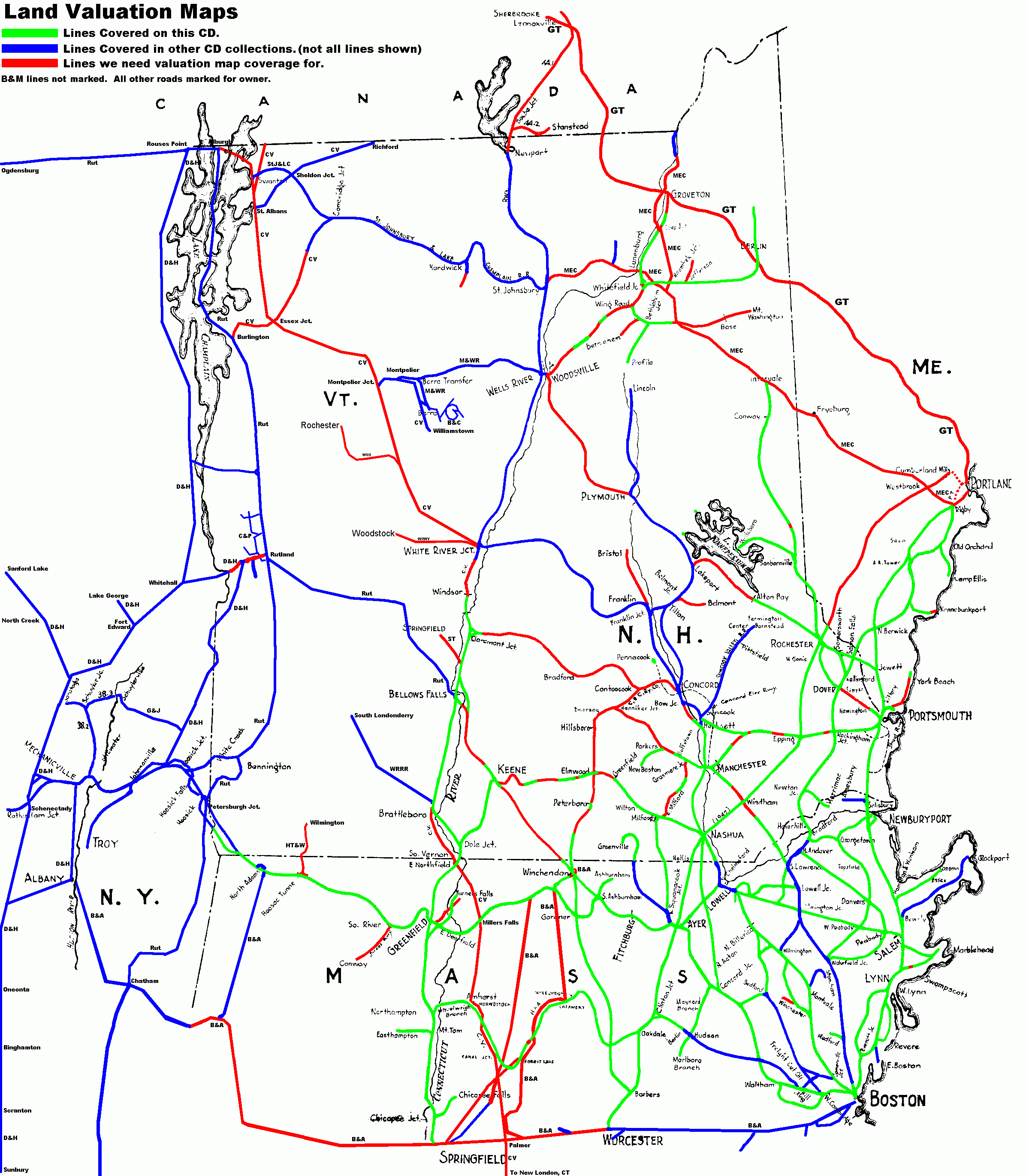
Right click and save image to see it in full size for easier reading. All new map areas included are in green.
![]()
Boston & Maine coverage map for Dropbox orders ONLY:
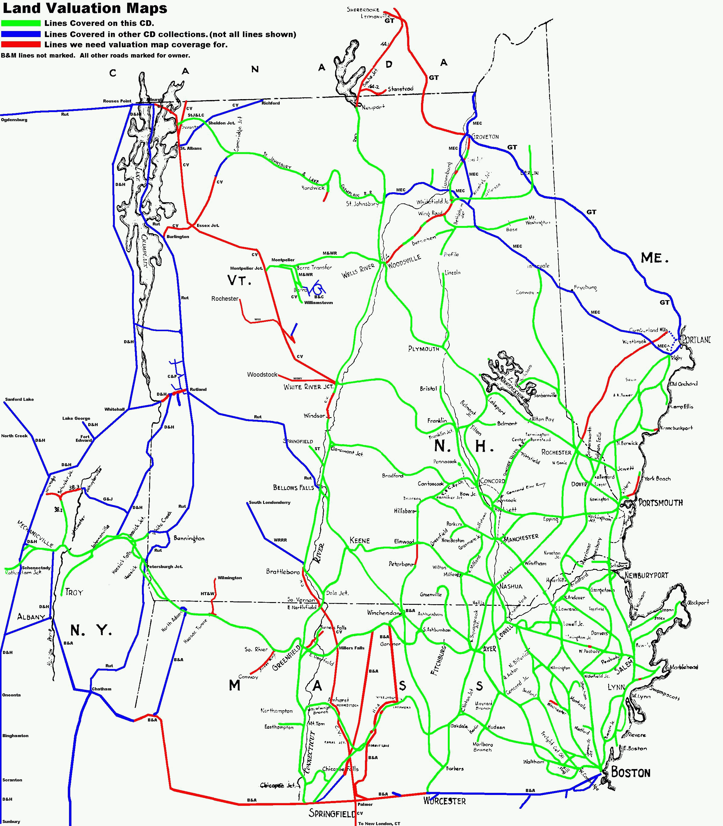
Right click and save image to see it in full size for easier reading. All new map areas included are in green.
![]()
Order your copy today by mailing $10 + $2 postage to:
Scott J. Whitney
78 Goret Dr.
Colorado Springs, CO 80911
NOTE 1: International mail orders must include $4 additional postage to Canada & Mexico, Total postage $6.
(NOTE 2: ALL International mail orders outside North America must be by Dropbox download only.)
Or use the handy PayPal links below:
![]()
