Track Charts - Volume 7 - Rev. 2 - $10*
NEW YORK CENTRAL RAILROAD
Hudson, Mohawk and Syracuse Division Areas.
*Now
available as a direct download via Dropbox®! See main NMRO Products page for
details.
NMRO is offering ONE (1) compact disk containing almost 1400(!!) images of land valuation maps New York Central Railroad on both the east and west sides of the Hudson River in both New York and New Jersey. We describe this area covered as all NYC east of Chittenango on the West Shore RR route, Buffalo on the Water Level Route to Albany and thence south to New York City (Boston & Albany is covered in T.C. Vol. 6). It includes ALL divisions and branch lines including those to Montgomery, Oneonta, Chatham, Troy and others.
Since
its demise, the charts and drawings of the New York Central Railroad have long
been sought after by enthusiasts. Most of them are out there but are expensive
to obtain and difficult to find. At last, through the generous donations of
fellow rail historians, much of this data has now been processed and is
available on compact disc. Please, make note of the sample images
provided as they just a small sample of what's inside. If you are like us here
at NMRO, you will likely find out things that you never knew before about
railroading in these areas. Did you know that the Boston Hoosac Tunnel &
Western had actually acquired right of way west of Rotterdam Junction? We
didn't! The coverage map shows the lines covered by this CD.
This
CD contains land valuation maps for the following railroad: NEW YORK CENTRAL.
Image
Details: Resolution of most all images is in 2 color GIF format at 9950 pixels
wide. If you were to
try and buy these track maps anywhere else in paper form it would cost you
THOUSANDS of dollars!!! NMRO Products proudly believes that railroad
information should be shared as reasonably as possible. Clarification: The data
is FREE because it is public domain. NMRO merely does the leg work for you.
![]()
NEW YORK CENTRAL Coverage Map

NEW YORK CENTRAL - Harmon, NY - Valuation Map Sample

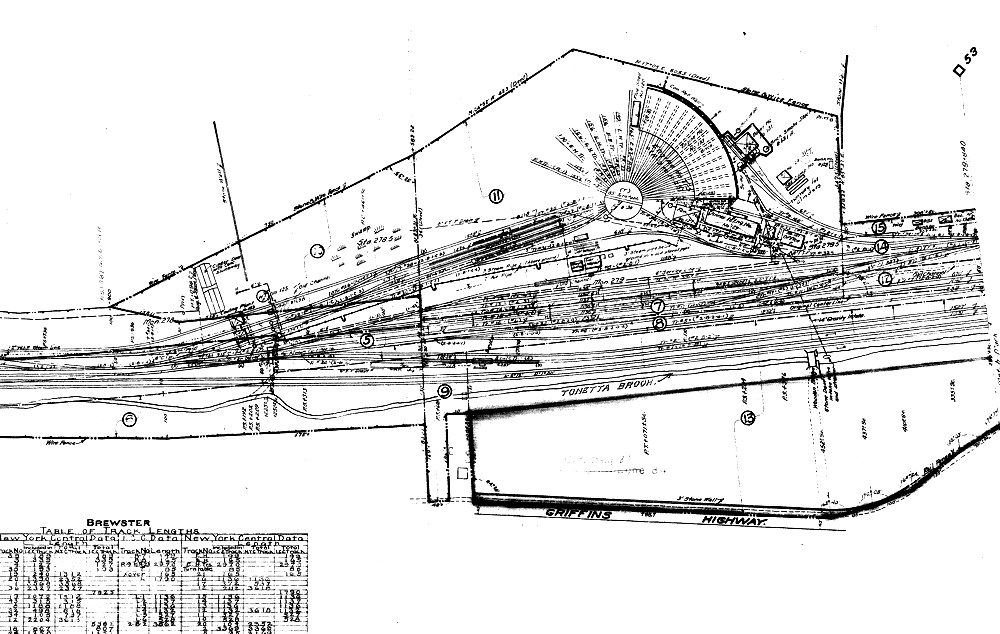
NEW YORK CENTRAL - Brewster, NY - Valuation Map Sample.
Order your copy today by mailing $10 + $2 postage to:
Scott J. Whitney
78 Goret Dr.
Colorado Springs, CO 80911
NOTE 1: International mail orders must include $4 additional postage to Canada & Mexico, Total postage $6.
(NOTE 2: ALL International mail orders outside North America must be by Dropbox download only.)
Or use the handy PayPal links below:
![]()
