NMRO
TRACK CHARTS
The NMRO Track Charts project:
It started as a seemingly simple project. I was working for a northeastern shortline operator (retired from there after 37 years!). We had just taken over operation of a 100 mile+ piece of railroad and had no track charts showing grades and curvature. The section of railroad had once been owned by the Boston & Maine Railroad but 2/3 of it had been turned over to the Canadian Pacific later in life. Oddly, none of the B&M track profiles could be found for the CP section so I sent out feelers. Finally, one very generous soul surfaced and said that he had what I needed. At that point he also said he had 99% of the rest of the Boston & Maine and asked if I wanted copies of everything. I was elated! Knowing that purchasing track charts and the like via e-Bay and other sources was very expensive (sometimes costing upwards of $100 for a single rail route) I vowed to make them much more affordable to the average railfan. Thus, the NMRO Track Charts program was born. Since that time numerous individuals have stepped forward and passed along material toward the project. The original release was just a portion of one CD and had nine different updates before it was full. Now, the collection is a massive 18 CD's large and also now is on direct download via Dropbox. All the proceeds derived go to the costs of maintaining the NMRO website, the Dropbox and for the production of more collections. Yes, Mama gets to go out to dinner to keep her happy with all the time I spend working on it! Just part of the cost of doing business as you know!
![]()
Track Charts Volume 1 - Revision #9
Northeast Railroads - Part 1
The CD collection that started it all!
A huge selection of charts and data from all over the Northeast.
Tracks Charts - Volume 2 - Revision #2
New York, New Haven & Hartford Railroad
Condensed Profiles, Land Valuation Maps and Detail Maps
West of Central Vermont Rwy.
![]()
Tracks Charts - Volume 3 - Revision #2
New York, New Haven & Hartford Railroad
Condensed Profiles, Land Valuation Maps and Detail Maps
East of Central Vermont Rwy.
Track Charts - Volume 4 - Revision #2

Delaware & Hudson - Land Valuation Maps
Nearly the entire D&H including lines aquired after 1980.
Track Charts - Volume 5
Delaware Lackawanna & Western
550+ Land Valuation Maps
New York City to Binghamton, NY.
Track Charts Volume 6 - Revision #2
Northeastern Railroads - Part 2
Northeast Railroads Valuation Maps and Data Charts.
Track Charts Volume 7
NEW YORK CENTRAL RAILROAD
Land Valuation Maps -
Hudson and Mohawk Rivers areas NYC to Buffalo.
Track Charts Volume 8
Railroads New York City & Westward to Binghamton, NY.
New York, Ontario & Western
New York, Susquehanna & Western
Erie Railroad - East of Binghamton, NY
1300 images of Land Valuation Maps & track profiles.
Track Charts Volume 9
Erie Railroad - West
1536 images of Land Valuation Maps West of Binghamton, NY.
Track Charts Volume 10 - Revision #3
Northeastern Railroads - Part 3
Now 1554 images of Land Valuation Maps and other material.
Track Charts Volume 11 - Revision #2
Northeastern Railroads - Part 4
Boston & Maine
Erie Lackawanna
Nickel Plate
Penn Central
Pennsylvania
Nearly 1000 files of Land Valuation Maps, track profiles and more.
Track Charts Volume 12
Boston & Albany Railroad
Over 1500 files of Land Valuation Maps and Track Charts.
Tracks Charts - Volume 13 - Revision #2
Northeast Railroads - Part 5
Over 900 Land Valuation Maps.
Over 800 Track Charts and other detail maps.
Featured Railroads: Rutland, B&M, StJ&LC, CLP, B&C, West River RR.
Sandy River & Rangley Lakes.

 Track Charts Volume
14*
Track Charts Volume
14*
Boston & Maine Land Valuation Maps
 Over 1450* files of Land Valuation Maps for New England.
*NOW A NEW SPECIAL OFFER - PROCEED TO SEE!!
![]()
 Track Charts - Volume 15
Tennessee Railroad Land Valuation Maps
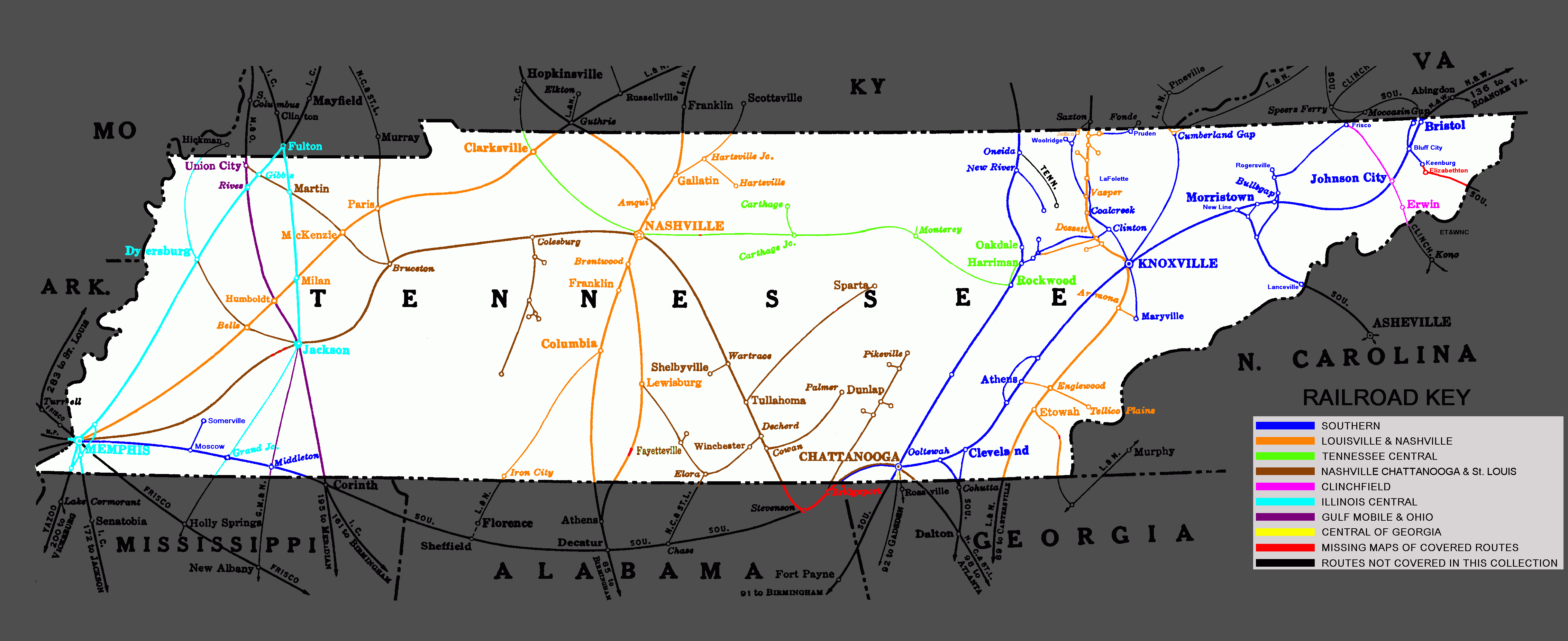
1950+ maps covering nearly the entire state!!
![]()
 Back to the MNRO Products
Main Page
Back to the MNRO Products
Main Page